Australia’s history of settlement could have been vastly different
...if only Cook had realised he’d struck gold on Possession Island
by Island Life
The gold, they say is plain to see,
I can’t imagine ever,
How Captain Cook could overlook
The gold at the Endeavour.
So wondered an anonymous rhymer at the port of Cooktown in the early 1870s when that flood of gold-fevered diggers rushed to the Palmer River.
But there was really very little to wonder at. Even as the crow flies, the mouth of the Endeavour River where Lieutenant James Cook beached his ship in June 1770, and the golden reaches of the river that William Hann would, in 1872, name the Palmer, were at least 100 kilometres apart.
That ‘Cook could overlook the gold at the Endeavour’ is not even open to discussion as the Endeavour River wasn’t then, and isn’t today, worth exploring for gold.
But questioning Cook’s lack of observation isn’t quite as wide of the mark as it appears.
On the 22nd of August, 1770, the Endeavour weighed anchor off a small island a little south-west of the top of Cape York. The island was known to the natives as Tuidin but was named Possession Island by Cook.
From a small landing craft, a party including Joseph Banks, Daniel Solander and James Cook stepped ashore.
The first task was to excavate a posthole in order to secure the flagstaff from which would flutter the old English bunting, the mark of possession of the entire eastern coast of New Holland, as Australia was then known, in the name of King George III.
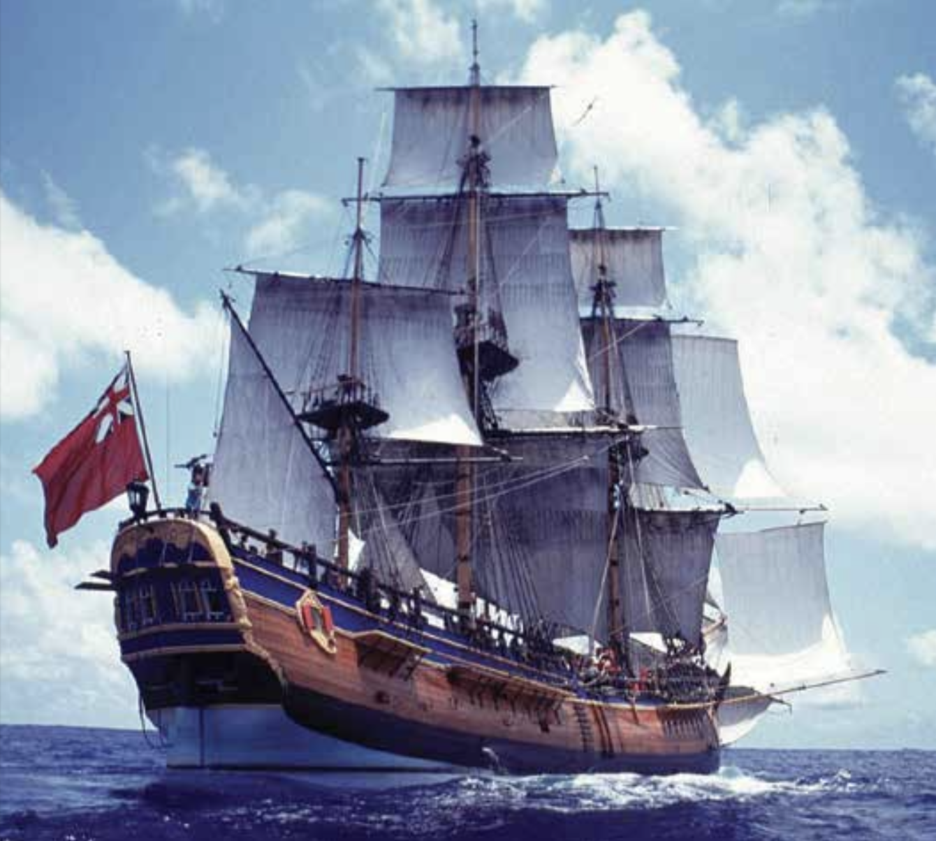
Replica of the barque HMS Endeavour
UNIQUE IN THE ANNALS OF POSTHOLE DIGGING
The thing about this particular posthole excavation, possibly unique in the annals of posthole digging if there is such an animal, was that they dug into a reef of visible gold!
Cook was looking for a passage to the Indian Ocean when he came across Possession Island and decided to conduct the little flag-raising ceremony on the island before sailing off into the setting sun.
But what really concerns us is whether James Cook and party, in their haste to climb the hill, plant the flag, regain the Endeavour and set sail, missed seeing the gold that was there in the ground they dug. My own view, and it is only that, is that they did see the gold but failed to recognize it for what it was. Others disagree, claiming Cook’s party did not see any gold. I have always found this a strange view but I’ll discuss that later.
There is no doubt that Cook was in a hurry. “The gentlemen immediately climbed the highest hill”, recorded Cook’s biographer the Rev. Dr Andrew Kippis. The words ‘immediately’ and ‘highest’ were all important. “These circumstances afforded him peculiar satisfaction” Kippis further wrote. Cook’s hilltop lookout showed him clear water to the west and the passage to the Indian Ocean. There was also no longer any doubt that New Holland and New Guinea were separate entities.
In the name of King George III, he had possessed the whole of the east coast of New Holland “from latitude 38 degrees to latitude 10 degrees and one half south” and now he wanted to go home. All was haste and, in his haste, it is very much on the cards that Lieutenant James Cook altered the direction of Australia’s evolution as a nation.
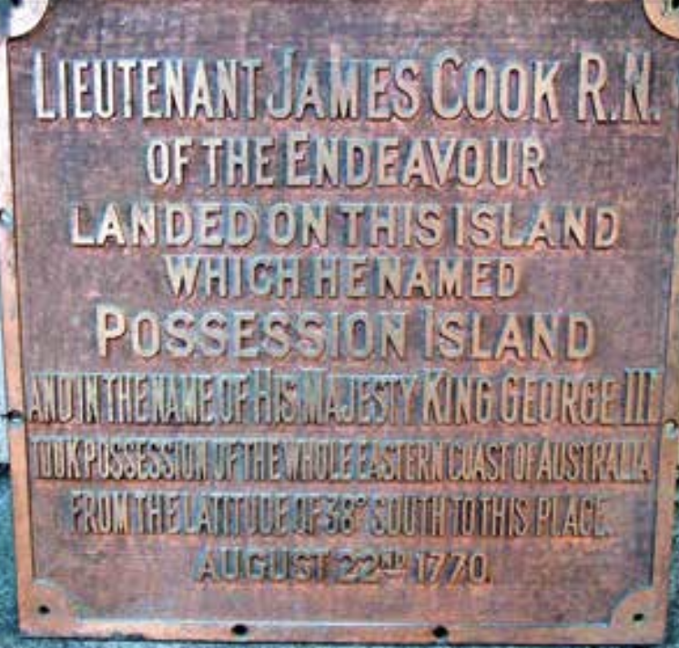
The original bronze plaque commemorating Cook’s taking possession of the east coast of Australia in the name of King George III, was stolen by vandals some time during the early 1970s and allegedly used as a barbecue plate. In 1988 The Torres Strait Historical Society erected a monument with the same wording, that had less appeal to those desperate for a sausage sizzle. Also below:

DR ROBERT LOGAN JACK’S FAMOUS BOOK
In Dr Robert Logan Jack’s famous book ‘Northmost Australia: Three Centuries of Exploration, Discovery, and Adventure in and Around Cape York Peninsula, Queensland’ published posthumously in two volumes in 1921 and 1922, the author wrote the following passage:
“In 1895, in the course of a trigonometrical survey designed to connect Thursday Island with the mainland, Mr Embley landed on Possession Island, where he observed a quartz reef, containing visible gold, standing out boldly from the coral. He traced the reef to the highest point of the island, the point on which Captain (sic) Cook had set up his flagstaff when he formally took possession of ‘New South Wales’ for Britain in 1770. Mr Embley and others worked the reef for some years. The first shaft was sunk where Captain Cook’s flagstaff had been planted....From 1897 to 1901, inclusive, Mr. C. V Jackson gives the crushing returns from Possession Island as 3,365 tons for 2,480oz of gold. Had Captain (sic) Cook caught sight of the gold which lay beneath his feet when he landed on Possession Island, could the boldest flight of fancy have ventured to predict the future history of Australia? If, instead of convicts in the southern part of the continent the first settlers had been gold- miners pushing their relentless way from the extreme north and making stepping stones of one fresh goldfield after another, along what lines would the occupation of the island-continent have developed?”
And there you have it. If Cook had reported gold at Possession Island there is every chance that, at a time when nations were in often deadly quest of the yellow metal, Australia would have been developed from the north, gold mines being opened in a southerly direction including Packers Creek, Iron Range, Claudie River, Bairdsville, Buthen Buthen, Blue Mountain, Rocky River, Coen, Ebagoolah, Lukin River, the Starcke fields, Potallah, Alice River, Palmer River, Hodgkinson, Etheridge, Ravenswood, Charters Towers, Gympie, Elbow Valley and a swathe of fields between. As it was, the Far North’s and Queensland’s gold in general sat idle for many years and development came from the south.
There must have been some 150 goldfields located between the tip of Cape York and Brisbane over the years to come – perhaps more.


CAUSE HIM TO MISS THE OBVIOUS
But did Cook’s hurried climb to the top of Flagstaff Hill and equally hasty departure from the island cause him to miss the obvious? Perhaps, but I don’t think so. And if not, why not? Certainly, gold was not reported as being found on Possession Island in August 1770 but Cook, Banks and Solander were observant men. It was paramount in their professions. Gold lay at their feet and I am sure they saw it, but in their desire to quickly do what had to be done and depart, they failed to observe it closely enough. That’s a strange statement, I admit, but the whole thing was strange to me for many years until one day, on the other side of the world, the penny dropped. The pieces of the puzzle fell into place.
While visiting the UK in 1988 and walking the moorlands, cliffs and beaches about Whitby, Yorkshire, the same paths James Cook himself had walked as boy and young man, I found gold and plenty of it – plenty of Fool’s Gold that is, pyrites. It was there in abundance. I found it as coatings on other rocks and in concretions.
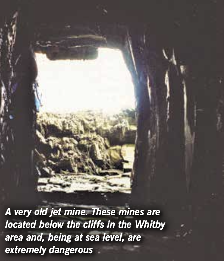
I found it in old jet mines and even in that gem material itself. I found it in coal imbedded in the cliffs. I even found fossil ammonites that had been replaced with it. I discovered that in Cook’s country, pyrites was very, very common.
(Note: Jet or lignite is not a mineral in the true sense of the word but is derived from decaying wood under extreme pressure, thus it is organic in origin. Just like coal. The name ‘jet’ derives from the French ‘jaiet’. Jet is black or dark brown and may contain pyrite inclusions.)
Those paths Cook had trod had showed him pyrites aplenty. He had seen it since his days as a young farmer’s son and I am convinced that in his haste, the genuine gold at his feet on that far off day of 22nd of August, 1770, was seen by the great navigator as pyrites, Fool’s Gold, and that is the reason why the course of Australia’s history likely took the direction it did.
A monument was erected on Possession Island but was vandalized with the original plaque being stolen. A new monument was erected in 1988.

The ‘seam’ rocks in the cliff (centre) are concretions. Many of these are found in the Whitby region and many contain vast quantities of pyrites or Fool’s Gold